We cross our bridges when we come to them and burn them behind us, with nothing to show for our progress except a memory of the smell of smoke, and a presumption that once our eyes watered.(Tom Stoppard, Rosencrantz and Guildenstern are Dead)

Blue line with yellow dots = Munda Biddi Trail.
Image for illustration only. Important information has been erased from this map. Do not use.


It was 9° C (48.2° F) at 3 AM.

Got up at 6:50 AM.
Temperature 10° C (50° F)
'Had a deep and restful sleep. The sleeping platforms here are better sheltered from the wind compared to many of the other huts (especially Dandalup).

In contrast to other campsites though, the toilet here — with a missing window pane, broken handle, and thick cobwebs everywhere — seems to be falling into disrepair.

A leisurely stroll back to camp for breakfast.


The Primus 4 season mixture boils water a lot faster than the Jetboil 3 season mix. I am unsure if this stems from it being able to maintain a higher gas pressure over a longer period of time (due to its larger volume) or a fuel mixture that burns hotter.


The zipper for my medicine / supplements bag came off. For SGD$2.50, I guess I can't really complain.

What the hell happened to you? You look like you got hit by a truck!
Oh, yeah? You should've seen the other guy...


At Yarri hut someone described it as long green tunnels.
Ah, I've been quoted :-D


Oui, mon capitan!




The Red-tailed Black Cockatoo's feather found a new home in the box.

'Left behind a can of gas and a pack of antiseptic wipes for the hut's next occupants.

What others left inside the box :-0

I ride on a hard carbon fiber saddle (Sella Italia Flite, sans leather and padding) for hundreds of miles off-road, but sit on a Z-Seat cushion seat at camp. Yeah, I'm twisted like that.
You heard of Iron Chef?
Well, mine's iron ass :-P

Other butt-masochists here (wood), here (metal), here (stone), and here (everything else).


Maintenance issues
Rear drive-side brake pad dive.
Headset loose.
Stem faceplate bolts loose.
Rear brake boss bolts loose.
Saddle clamp bolts loose.
All bolts were tightened to specifications with a calibrated torque wrench prior to tour.
Encountered an access issue with the Topeak Alien DX. With the (rare as hen's teeth) Shimano V-brake Booster, Avid Ultimate SD Brakes, and Blackburn Mountain Rack, tightening or loosening the M6 brake boss bolt beyond 1/16th of a turn at a time is near impossible. Here, a standalone, long-armed, 5 mm Allen key is a blessing.
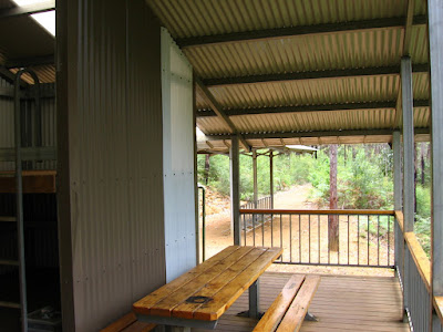
The wood used for Yarri Campsite is gorgeous. It's really too bad that some idiot's stove damaged one of the tables :-(


"Yarri" is the Nyoongar name for the Blackbutt tree (Eucalyptus patens Benth.) found in the area.

A trail re-alignment north of Yarri Campsite (strange, it didn't seem that way when I rode it yesterday).

'Had 3 servings of mashed potatoes and a 3rd cup of coffee as my 2nd breakfast.
The 8 muesli bars will serve as lunch as I ride through the afternoon.

Unlike the former campsites, where the huts are located on a branch off the trail, Yarri is situated on the track.

Set off at 1:50 PM.
Altimeter reading 1105 ft (337 m)
Temperature 25° C (77° F)


Blackbutt eucalyptus trees all around.

The trail is nice, but some sections have been damaged by trail bikes (scramblers, motocross, dirt bikes, et cetera). If nothing is done, sections like these will gradually be made unridable.
Caressed by the wind,

Ah! Yes, one of these. Preferably a higher tech version with ruggedized solar panels, rechargeable lithium-ion batteries, and regenerative braking + oscillating spring coil mechanism that converts vertical motion to electrical power, remote 30 mm cannon...

Trail overgrown with a shrub of the genus Lasiopetalum (species unknown).


Some eye protection necessary.


Large gum nuts from "Red Gum" or Marri trees (Eucalyptus calophylla or Corymbia calophylla) on the trail suck up a lot of power; it's like riding on hard gummy bears. According to Steve, these "Honky nuts" are also dicey to walk on.

Trivia: Marri is also known as the Medicine tree to the Aborigines because the red gum or 'kino' contains tannin, an antiseptic agent. It was sprinkled onto sores and wounds to prevent bleeding, infection, and ward off flies. Mixed with water, it served as a mouthwash or disinfectant. Eaten in small quantities or dissolved in water, the dried form of the gun was used to treat diarrhoea and dysentry.
Soaked in water, the flowers of the Marri tree yield a sweet, honey-like beverage the Nyoongars called numbit.
The powdered gum was also used to tan kangaroo skins.
(Source)


More fun.

There is a track going around it. It goes uphill though.

Cloe, Bob, and I elect to do the limbo instead.


3:20 PM. It has been raining steadily for the last hour. I am cold and wet. And dreaming of steak and potatoes, and a good pint of stout (fine when you're asleep; not so when you're riding).
On the plus side, there are no flies.

It's strangely liberating when you reach a state of total saturation, when every layer of clothing has absorbed as much liquid as it possibly can, when you feel rivulets trickling down your pruney skin, when pools of water slosh in your shoes. When that happens, you no longer have to detour around puddles or fear the splash from passing cars. You can't get any wetter than you already are.(John Flinn)

Riding alone through a forest in the rain is surreal: everything goes into hiding. It's like a loveless marriage — it's not a divorce, but you know it's there :-P

4:13 PM.
Mornington Road.
It stopped raining :-D

4:25 PM. A local couple in a pickup, with a pair of trail bikes in the back, stopped to ask directions to Collie :-0


Trail lined with prickly Gold Water Bush (Bossiaea aquifolium Benth.).


Timing is everything.
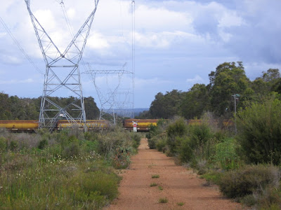
Freight train from Worsley Refinery.

More wildflowers.

Eastbound Gastaldo Road.

Southwest bound Gastaldo Road.


Tracks leading east to Worsley Refinery.

Tracks leading southwest.
The trail briefly parallels the track (yellow marker on left mid-ground).

Back into the bush.
At the end of the clip, I was momentarily distracted by what Aushiker dubbed, the Redneck Holiday Villa, a campsite littered with beer cans and broken glass.

As I captured it on video, I didn't take a picture. (Image credit: Aushiker.)

Crossing one of the many brooks feeding Hamilton River.

'Tempted to ride it but with a considerable incline on the other side, a 39.7 kg (87 lb) trailer, and so close to my destination, I demurred on the side of caution.

7 PM.
Hamilton Wallis Formation.


A stand of Sheoak (Allocasuarina fraseriana) softly carpet the trail; I ride with reverent, hushed breaths, in dryadic quietude.


Cloe gets a taste of Ivy's lilliputian jaunt through the redwoods of North California (winter / summer).


Final approach to Collie.

Rustling in the breeze, the eucalyptus forest shimmers in her evening garb of green, gold, and black.

Overhead, cackling a veritable cacophony of mocking laughter, hoots, and manic croaks, Kookaburras (Dacelo gigas) announce dusk's approach, spurring my tired limbs to speed up.


7:45 PM.
One more turn.

A field by Collie Tallanalla Road.

The town of Collie in the distance.
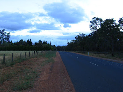
South towards Collie.

Now about the steak and potatoes I've been dreaming about...

Hull Road.

A grind up a steep slope on Ewing Street after this.
At the last turn (the streets which you are supposed to follow are largely unnamed in the map) I wasn't sure if I was supposed to go right or left. While I was figuring it out with the map and compass, a nice lady pulled to the junction and inquired if I was lost.
I let it be known that I was trying to find my way to Soldier's Park. The lady thought for a moment and then went, "Follow me." Although I cheerily pointed out that I would be unable to keep up with her vehicle, she gave assurance that she would go slow.
Well, slow to her V8 SUV meant 45 km/h. After riding over 44+ km through the bush, rain, sun, and wind, I almost blew a gasket trying to maintain a 40+ km/h sprint for over a mile — with a fully loaded trailer.
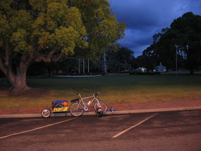
Southern Terminus of Munda Biddi Trail: Stage 1.
Soldier's Park, Collie.
Arrived 8:20 PM
Cateye AT-100
Altimeter reading at Soldier's Park 1010 ft (307.9 m)
Elevation climbed 1190 ft (362.8 m)
Distance forgot to record
3 hours 56 minutes 51 seconds
Average speed 7 mph
Maximum speed 26.4 mph
End temperature 17° C (62.6° F)
Cateye Enduro 8
3 hours 50 minutes 17 seconds*
Average speed 11.7 km/h
Maximum speed 42.5 km/h [Oops! Exceeded recommended speed limit for Bob trailer again.]
Distance 45.27 km
Cumulative distance 388.82 km (243 miles)

A bunch of teenagers were chatting by the curbside when I rolled in. Asking me where I'm from; how long I've been on the road; how do I manage to control such a long bike; they poked around Cloe and Bob, trying to locate the engine :-P
After helping me take some pictures, the teens chatted a while, giggled over my ridiculous rig, and then took off in their cars.

"Good job, mate!" a local in a ute congratulated as he drove past.

Cloe, Bob, and me.

Journal entry
As I completed taking the obligatory pictures at Soldier's Park, another trio showed up, one of them rattling over the brick-paved sidewalk on his skateboard. After curiously inquiring where I came from (
And, since I've been too busy cycling to take up martial arts lessons from Jet Li, Jackie Chan, or Chuck Norris...

9:15 PM. They showed me to Collie Motel; where to eat (Golden Bowl Restaurant); and where the pub is. Outside the lobby, they even hung around, in case the rates are beyond my budget. Dillon did suggest an alternative: Collie River Valley Tourist Park, which is a little ways out of town, just over a couple of steep hills...
Thanks, but I'll pass on more climbing for today :-D

Despite my protests that the bags, bike, and rig are filthy — earlier, on the trail, I rode through a huge, hub-deep puddle that had a dead animal rotting beside it — the trio helped me carry everything to my room. And, despite not having had eaten by that late hour, they declined my offer to buy them dinner.
Thank you, guys!
:-D
After putting everything down, I took some cash, notebook, pen, and map, and went in search of dinner. As the path cuts across a dark, isolated railway crossing, I left my camera in the room.
At Golden Bowl Restaurant, contrary to the owner's advice, I ordered a huge plate of sizzling Szechuan Lamb (AUD$13.50), a large bowl of rice ($5.90), and a bowl of hot and sour soup ($4.50). I finished every everything. This is where I wish I brought my camera along — to prove that I'm not only capable of self-denial and starvation, but the rare, occasional gluttony well.

Back in the room, the sole survivor of the Great Szechuan Lamb Massacre.

An overview of Stage 1 of the Munda Biddi Trail, which I've just completed touring.

Stage 1 comprises of 3 sections:
Mundaring to Jarrahdale - Map 1 (103 km / 64 miles)
Jarrahdale to Dwellingup - Map 2 (95 km / 59 miles)
Dwellingup to Collie - Map 3 (134 km / 84 miles)
On-going work on the trail meant that the Munda Biddi Trail has progressed beyond Stage 1, beyond Collie.

As of mid-November 2008, approximately half of Stage 2 has been completed; linking Collie to Nannup, and extending the Munda Biddi Trail by another 165.1 km (103.2 miles).

Map 4 covers 139.1 km (86.9 miles) and breaks the journey over 3 days:
Collie to Nglang Boodja Campsite (46.5 km / 29 miles)
Nglang Boodja Campsite to Donnybrook (48 km / 30 miles)
Donnybrook to Nala Mia Campsite (44.6 km / 28 miles)
Nala Mia Campsite is located in Jarrahwood Townsite.

In this particular case, however, the term, "townsite," is rather liberally employed: as Bill and Perry discovered, the only facilities offered are the sleeping hut and a restroom. There are no shops here.

Winding through forests of Jarrah and Karri, the 26 km (16.3 mile) Sidings Rail Trail connects Jarrahwood to Nannup via an old railway line.

I am sorely tempted to push on, but:
- I am running low on cash (not a problem if I find an ATM or bank at Collie);
- memory cards for my cameras and video camera are almost filled (big problem as it might be tough getting more in a small town);
- lantern and headlamp are running on the 2nd (and last) set of lithium batteries (not a problem if I'm willing to purchase heavier alkaline equivalents);
- am tired (nothing a good night's rest won't cure);
- attempting this additional section means cutting it close to the departure flight date (potential big problem).
These, together with the trail advisory (its veracity I can attest to) mean that, even if I complete this half of Stage 2, I will:
- miss out on a lot of pictures and videos;
- have to start clobbering kangaroos and wallabies with my pump for food;
That, and I may very well end up taking more than the estimated 4 days to complete it. A delay anywhere might cause me to miss my flight, necessitating the purchase of another ticket out of Australia.
Sounds like an expensive ride.

Decision made, it's time to hit the shower and plan for tomorrow.
-10:55 PM
DATA
Start 1:50 PM
End 9:15 PM
Total 7 hours 25 minutes
Cateye AT-100
Altimeter reading at Collie Motel 1040 ft (317 m)
Elevation climbed 1210 ft (368.9 m)
Distance 28.3 miles (45.3 km)
4 hours 6 minutes 30 seconds
Average speed 6.9 mph
Maximum speed 26.4 mph
Temperature 9° C - 25° C (48.2° F - 77° F)
Cateye Enduro 8
3 hours 58 minutes 28 seconds*
Average speed 11.5 km/h
Maximum speed 42.5 km/h [Oops! Exceeded recommended speed limit for Bob trailer again.]
Distance 45.98 km
Cumulative distance 389.52 km (243.45 miles)
* = The Enduro 8 doesn't appear to keep time or give a speed reading below speeds of 3.6 km/h (2.25 mph). E.g. when I'm pushing Cloe and Bob up steep hills. Distance, however, continues to be tracked.
No comments:
Post a Comment