Pain is a very precious gift. Do not waste it.(Martha Singleterry)

Blue line with yellow dots = Munda Biddi Trail.
Green line with yellow dots = Touring route.
Red line with yellow dots = route from Holiday Haven, Jarrahdale.
Image for illustration only. Important information has been erased from this map. Do not use.


Woke up just before 6 AM.
It was 15° C (59° F) inside the cottage.
Left Holiday Haven at 9 AM.
Temperature 14° C (57.2° F)
Here's Jarrahdale Tavern in the morning. Their friendly staff recommended Holiday Haven when I was looking for accommodation 2 days ago.

3.01 km and 110 ft of climbing later.

A very nice bike (okay, both bikes).

Inside the store.


The coffee was heavenly.

Resumed journey at 10:15 AM.
Temperature 25° C (77° F)

Back into my element. (You can keep your cheap suits, I'm much happier being like Billy Goat aka George Woodard.)

Descending to Serpentine River.

Descent to Serpentine River Part I.
Descent to Serpentine River Part 2.

Trail joins Scarp Road.


Serpentine River.
Altimeter reading 475 ft (144.8 m)

A hard push up Scarp Road.

More pushing after leaving Scarp Road.


12:36 PM.
Altimeter reading 670 ft (204.3 m)
Excuse the mesh hat. It's 32° C (89.6° F) and a whole lot of pushing. That, and the flies are more numerous than whiners at a Charismatic convention.

A brief downhill.
(Oh, you teaser, you!)

1:30 PM. Lunch.
'Had half of the ham and cheese sandwich from Jarrahdale General Store.
Altimeter reading 620 ft (189 m)
Elevation climbed 640 ft (195 m)
Distance 10.6 km (6.6 miles)
Temperature in the shade 25° C (77° F)
No siesta this time, just lots of pushing.
Why go to a gym when you can do this? :-P


Like lace on a sinuous body, shadows grace and accentuate the trail.

Descending to Kingsbury Drive.
I actually pushed the bike + trailer back up for a 2nd descent just to film it.
:-P
At 3:15 PM — 14.7 km (9.2 miles) from Jarrahdale and 750 ft (228.7 m) of climbing — the trail rejoins Kingsbury Drive, whereupon I mistakenly turned southwest instead of southeast, clocked an extra 2 km, and bagged an unnecessary climb.

Here and there, the landscape turns phantasmagoric.

Down the rabbit hole we go...

Passing by more burnt out hulks.


A rollicking downhill, then... a sand bath.
#%@&! What the heck am I?
A Chinchilla?

Wildflowers surprise and delight like floral fireworks in a landscape of brown, green, black, and gray.

A lemon orchard (I think) lies to the right, and a pine plantation to the left.


Trail narrows.

The leaves of some shrubs are pointed and sharp. Ovey!
That was nothing compared to a small fallen tree across the trail that I had to muscle the bike and trailer over. Note to self: bring a machete (or a lightsaber) next time.
The trail markers disappeared for a while, necessitating frequent stops to double-check with the map and compass.

Never look a gift horse in the mouth: take the touring route, young Padawan.

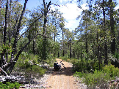
Not much of a gravity climb here as it's dicey to exceed 38 km/h (23.8 mph) with a fully-loaded trailer on a pea gravel road.
'Getting rather good at unclipping, hopping off, and running away when the front wheel washes out.
According to [Jim] Hyde, men are less likely to get hurt adventure riding because — as in relationships — men have no problem jumping off a falling bike.(Neil, Dan. "It's hard being an easy rider." Los Angeles Times May 22, 2009.
"Women tend to go down with the ship," he observes, only half-kidding.

A wider front tire would have worked better on the Munda Biddi Trail. The 2007 Fox manual specifies the maximum tire width to be 2.4 inches. However, any tire wider than 2.3 inches will have to be carefully measured using the steps outlined above before use. Disregarding the procedure may result in equipment malfunction or failure.
Trail narrows into singletrack after leaving Boyd Road.

6:55 PM.
5 km from Dandalup Campsite.
Singletrack leading to North Dandalup Dam.

Asphalt!
(And, oh yes, water.)


Riding across North Dandalup Dam.

People ask, how can I carry such a heavy backpack (5 to 8 kg Camelbak HAWG) for such long hours, over so many days?
What can I say?
I've got a strong back, built over many years of immoral activities.
:-P

Dandalup Picnic Area.


The pool lies 170 m (557 ft) below).

Sunset over North Dandalup Dam.


Riding toward Dandalup Campsite at dusk.

Bad idea.

The descent to Dandalup Campsite was insane: narrow singletrack with a steep gradient, and a deep (1 to 2 feet deep) center gully that's a foot wide. On either side, the ground slopes / chamfers into the gully. To complete the fun, prickly bushes line the trail. Tree roots jostle for the opportunity to send you tumbling down the hill. All I had in my backpack was my Gerber Tracer Dual LED Headlamp, which saved my butt on my first Mount Hamilton Ride. It saved my butt this time again (in my infinite wisdom, the more powerful water resistant lights were safely sealed — and inaccessibly packed — at the bottom of the Bob Dry Sak). I should have purchased that Black Diamond Spot Headlamp.
Wheeling into Dandalup Campsite after dark.


Dinner!
Mexican Chicken with rice, tortilla chips, and a steaming bowl of French Onion Soup.

Dinner reading material.

I concur. The descent is nuts, even more so with a trailer; on the other hand, panniers might get torn though.


I like B. Rock's comment.
(Like my misspelling? The lemmings on a certain tropical-island-paradise-with-the-death-penalty constantly complain that I'm too much of a grammar nazi. Well, I'm not being a grammar nazi in this entry. How do they like it now? Eh?)


At least the video of the singletrack came out :-D


Under the logbooks: generous souls built up a stash of rations for the hungry biker low on food. It is acts like these that impress me — random acts of kindness — and not bling.
Journal entry
Hard ride. No journal entry.
From notebook
Reached Dandalup Campsite at 8:30 PM in the dark after brute forcing the trailer down a steep downhill from hell — with a deep center gully (with sloping V-sides too!).
Not much water in the tanks.
Wind blows very strongly.
Lower side of sleeping platform closer to hillside has big spiders living underneath.
DATA
Start 9:00 AM
End 8:30 PM
Total 11 hours 30 minutes
Cateye AT-100
Altimeter reading at Dandalup Campsite 445 ft (135.7 m) Erroneous.
Reading next day 905 ft (276 m)
Elevation climbed 1640 ft (500 m)
Distance 25 miles (40 km)
5 hours 15 minutes 25 seconds
Average speed 4.7 mph
Maximum speed 21 mph
Temperature 7° C - 32° C (44.6° F - 89.6° F)
Cateye Enduro 8
4 hours 50 minutes 4 seconds*
Average speed 8.6 km/h
Maximum speed 33.5 km/h
Distance 41.15 km
Cumulative distance 172.23 km (107.64 miles)
* = The Enduro 8 doesn't appear to keep time or give a speed reading below speeds of 3.6 km/h (2.25 mph). E.g. when I'm pushing Cloe and Bob up steep hills. Distance, however, continues to be tracked.

No comments:
Post a Comment